Mapping Palmyra
About This Project
This paper and its accompanying digital humanities components were created as my final assignment for Professor Fotini Kondyli's Spring 2020 seminar, Mediterranean Capitals. This project contributed to my MA thesis research, and informed a chapter of my thesis paper.
This project explores different perceptions of the city and its value through representations of monuments destroyed by ISIS, particularly in Palmyra. It considers projects undertaken by both digital organizations and contemporary artists in Palmyra and greater Syria and Iraq. The case studies presented include both high-profile projects and grassroots initiatives, and raise questions surrounding imagined urban identity.
While previous studies on the destruction and memory of Palmyra investigate the role of digital technologies within cultural heritage, this paper emphasizes site selection as a means through which to promulgate certain narratives. To examine both digital and artistic reproductions of Palmyra, I use both archaeological evidence and mapping analysis using the software ArcGIS. Mapping provides an analytical means through which to better understand site selection and spatial connotations. This approach allows for an analysis of the significance of reproductions of Palmyra and the conflicted narratives crafted by various reproductions. The use of mapping provides this project with two key outcomes: first, that there are significant implications of reproductions of Palmyra exhibited in other cities, and second, that there is a disconnect between sites deemed most important by digital projects as opposed to those examined by contemporary artists.
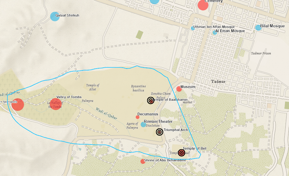
Map of Palmyra showing sites destroyed and sites digitally reconstructed
|
|
Mapping
Mapping provided this research on digital heritage with the advantage of examination through large-scale patterns. Through the development of a database and the use of mapping software, digital tools have allowed for each individual example of destruction and digital reconstruction to be viewed within a greater context. These models and projects do not exist in isolation, and their global reach is significant. Therefore, these maps provide a lens through which to analyze individual works within the context of an expansive geographical and chronological history of the life and afterlife of heritage in Palmyra and throughout the Middle East.
I chose to map this data through ArcGIS in an effort to visualize the implications of destruction and reconstruction, particularly as it applies to the global reach of Palmyra’s Arch of Triumph. I have taken advantage of ArcGIS’s interactive features to enable viewers to engage with the data through scroll-over information and chronological animations. In order to clarify these maps, I have used modern names of places throughout the maps. Users can scroll over each point on the maps to find images and further information about the sites.
I chose to map this data through ArcGIS in an effort to visualize the implications of destruction and reconstruction, particularly as it applies to the global reach of Palmyra’s Arch of Triumph. I have taken advantage of ArcGIS’s interactive features to enable viewers to engage with the data through scroll-over information and chronological animations. In order to clarify these maps, I have used modern names of places throughout the maps. Users can scroll over each point on the maps to find images and further information about the sites.
